
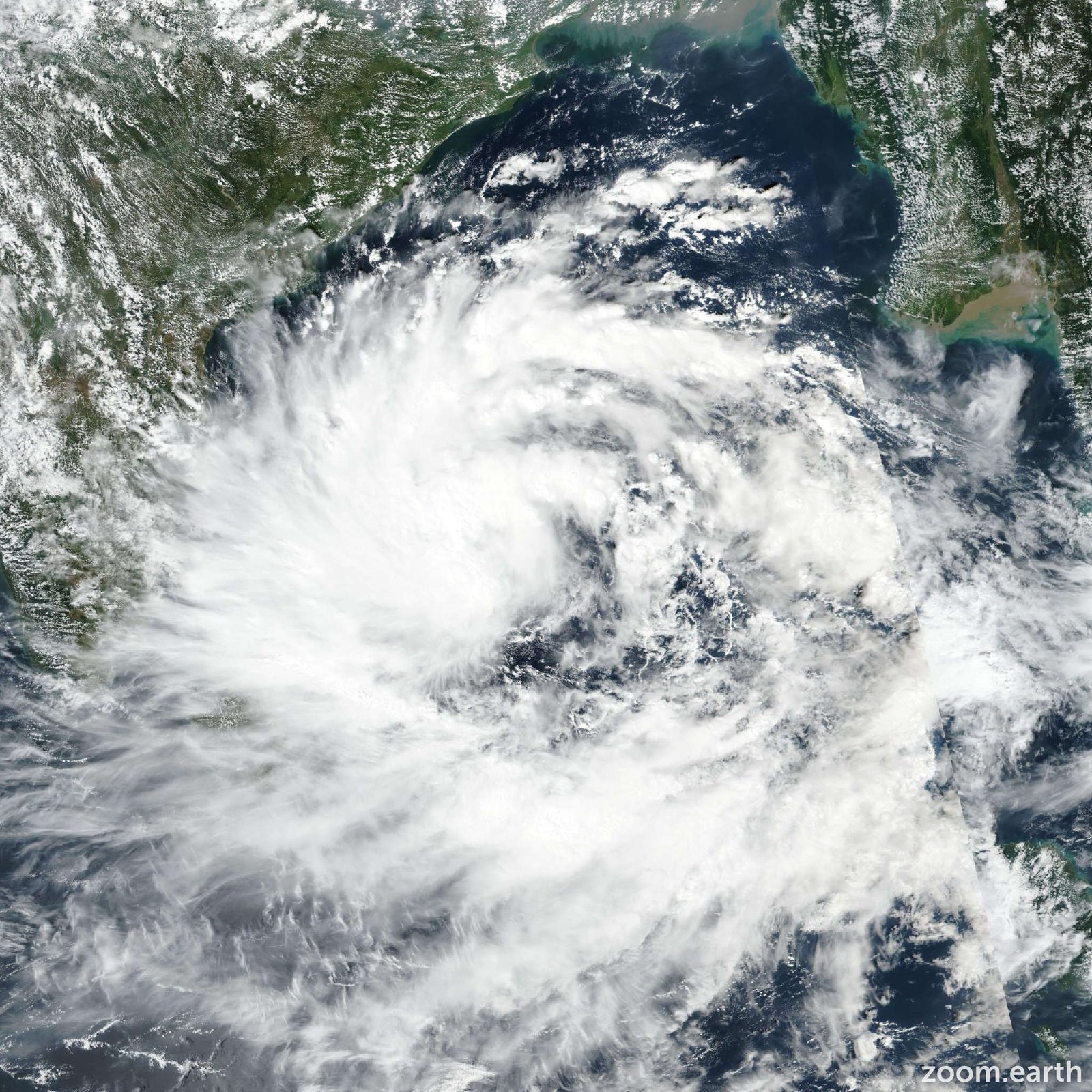
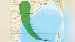
Cyclone Montha 2025 Update: A cyclonic storm called Cyclone Montha is actively forming over the southeast Bay of Bengal and is forecast to make landfall along the coast of Andhra Pradesh, India. According to the India Meteorological Department (IMD), the storm is likely to cross the coastline between Machilipatnam and Kalingapatnam, near Kakinada, on the night of 28 October 2025.
Authorities have issued red alerts for coastal Andhra Pradesh and parts of Odisha, signalling a high risk of heavy rain, strong winds, coastal inundation, and flooding.
Cyclone Montha 2025 Update: Forecast & Expected Impacts
-
Wind speeds are expected to pick up as Montha approaches land. Forecasts suggest gusts potentially reaching 90-100 km/h, possibly higher near the coast. Heavy rainfall is likely over several days. For example, in the regions of coastal Andhra Pradesh and Rayalaseema, rainfall over 210 mm in 24 hours is being warned for around 27-28 October.
-
Secondary impacts: Coastal surge, flooding of low-lying areas, waterlogging, disruption to transport and power, and danger to vulnerable structures.
-
In southern Odisha and Tamil Nadu, preparatory alerts have been issued since the storm may affect these regions as it moves inland.
Why This Storm Is Concerning:
Several factors make Montha especially worthy of attention:
-
The Bay of Bengal remains warm and favourable for the intensification of cyclones during this period.
-
The approach path implies significant coastal exposure, including dense populations, infrastructure, and some areas with limited evacuation options.
-
Heavy rainfall plus strong winds together raise the risk of flooding, storm surge, and landslides (especially if hilly terrain inland is affected).
-
Given past experiences in the region, even a moderately strong cyclone can lead to major humanitarian and economic consequences.
What Residents and Authorities Are Doing / Should Do:
For residents in affected zones (Andhra Pradesh, southern Odisha, coastal Tamil Nadu):
-
Stay updated with official bulletins from IMD and local disaster management.
-
Prepare for evacuation if ordered – identify nearest shelter, have essential supplies ready (documents, medicines, food/water, torch).
-
Secure property: clear gutters, anchor loose objects, trim weak trees, and avoid parking under tall trees.
-
Avoid venturing into low-lying and coastal areas during the storm; sea beaches and piers are particularly dangerous.
-
For travel plans: Expect disruptions to trains, flights, and road transport; sea conditions will be risky.
For local authorities & emergency responders:
-
Have evacuation centres prepared, with supplies of food, clean water, medicines, sanitation, etc.
-
Ensure power/back-up systems, communications (mobile/internet) remain operational.
-
Pre-position rescue teams, boats (if flood risk), ambulances, and medical support.
-
Monitor storm surge forecasts and issue targeted alerts for coastal inundation.
DWM Cyclone Watch Special Update – 11 |Date: October 28, 2025 | Time: 6:00 AM
Subject: Cyclone Montha Set to Approach Kakinada
==> Cyclonic Storm Montha is currently located 420 km east-northeast of Chennai and is expected to move north-northwest towards the Kakinada coast.… pic.twitter.com/ZLOWfVMWhV
— Delta Weatherman (Hemachander R) (@Deltarains) October 28, 2025
What Happens After Landfall?
Once Montha makes landfall and moves inland:
-
It will weaken, but heavy rainfall inland can continue for one or more days. Rivers may swell, and flood risk extends beyond the immediate coast.
-
Winds fade, but damage to structures, power lines, and communication persists — restoration efforts may take time.
-
Post-storm, there will be assessments: damage to homes, infrastructure, and agriculture; relief operations will begin.
-
Recovery may be slower in more remote or resource-constrained areas, so early planning helps.
Comparison / Historical Context:
While being mindful that every cyclone is unique, a point of comparison:
-
The earlier storm Cyclone Mocha (May 2023) struck Myanmar/Bangladesh with extremely high winds (~250 km/h) and caused widespread humanitarian impact.
-
Montha, by contrast, is not (at present) being forecast as extreme as Mocha, but the coastal Indian region is densely populated and so even a less-intense storm can produce major disruptions.
-
Forecasting and early warning capabilities are stronger now than in past decades, which helps preparedness.
Key Takeaways for October 2025:
-
When: Landfall expected late 28 October near Kakinada region; heavy rains start earlier.
-
Where: Coastal Andhra Pradesh (Machilipatnam–Kalingapatnam), then inland toward southern Odisha, and potentially spill into Tamil Nadu.
-
What: Wind speeds nearing 90-100 km/h gusting higher; rainfall may exceed 200 mm in 24 h in some pockets; flooding + storm surge risk.
-
Action: Monitor official alerts; secure property; evacuate if told; avoid coastal/low-lying zones; stay indoors when the storm arrives.
-
After effects: Even after landfall, rain and flooding may persist inland; infrastructure damage and power outages are likely; relief operations are likely to ramp up.
Cyclone Montha is a serious threat to the eastern coast of India in late October 2025. While the full strength it will achieve is still subject to change, the combination of heavy rain, wind, and coastal exposure makes it a situation to be treated with respect and caution. Proper preparation – at the individual, community, and government levels – can significantly reduce harm. As always, timely evacuation, heed to official warnings, and proactive safety measures will matter most.
ऐसे और भी National लेखों के लिए हमारे साथ जुड़े रहें! Khabari bandhu पर पढ़ें देश-दुनिया की ताज़ा ख़बरें — बिज़नेस, एजुकेशन, मनोरंजन, धर्म, क्रिकेट, राशिफल और भी बहुत कुछ।
Cyclone Montha Live Update: आंध्र प्रदेश, ओडिशा और तमिलनाडु में बढ़ा खतरा |